
This map is on view in Linking Asia: Art, Trade, and Devotion through April 1. Included with general admission.
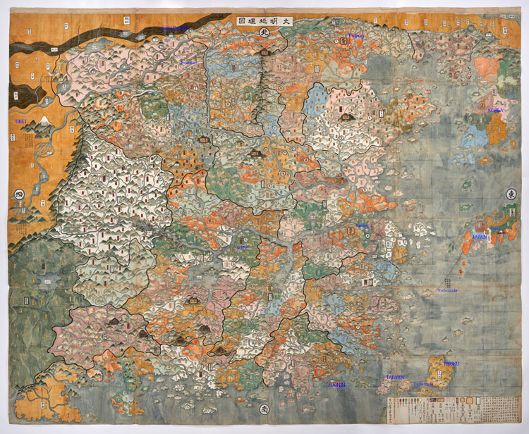
It was commissioned by a Japanese royal family whose origins go back to the 12th or 13th centuries. It was created in Japan in 1681. Although we do not know who painted it, the cartographer was probably Japanese and had access to knowledge of the Ming Dynasty “landscape” as well as classical Chinese writing. All of the characters in the map are scribed in classical Chinese. It was not unusual for cartography at the time to be copied from an existing source. Please bear in mind that 1681 is actually well into the Qing Dynasty. The Ming Dynasty ended nearly 40 years prior.
Depicted are the geographical relationships between China, Japan, and the rest of Asia – Korea, Gobi Desert, Tibet, present day Taiwan.
Knowledge of Art, Trade, and Devotion
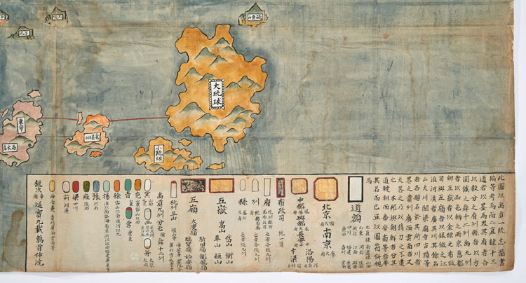
There were three capitals recognized during the Ming Dynasty: Nanjing – the ancestral capitol of China, Beijing – the recognized capitol seat of China, and Kyoto, Japan’s capitol. There are also two trade routes shown in the lower right portion of the map. The one further north was tightly controlled by the Ming Emperor as it was subject to piracy. The route farther south passes between Ryukyu (or present day Okinawa) and the mainland of China.
With the advent of the Qing, China effectively closed the door on rest of Asia and world. This map was perhaps “a commission of nostalgia” that reflected upon Japan’s understanding of the political landscape of East Asia, especially China. Japan and Korea really looked to Ming China for knowledge of art, trade, and devotion.
Unique Elements
What is particularly interesting about this map is that it is intended to be viewed from the front and has few pictorial elements. Many contemporary maps made in Asia were to be viewed from all sides and included detailed depictions of landscape and architectural elements. In addition, there is a legend in the lower right corner and direction markings for north, south, east, and west.
In the dozens of Ming and Qing Dynasty maps that I have viewed both at the Library of Congress and from online sources, none have color so brilliantly applied and in the manner as this Ming Dynasty map. Color seemed to become much more prominent as a means for identifying regions—as opposed to pictorial elements—in the latter 18th century and thereafter.